Contact us
Roxborough Area Historical Society Douglas County, Colorado
  • Events
  • About Us
  • Membership
  • Roxborough Area History
  • Silica Kiln and Railcar
  • Books/Presentation
  • Artifact Collecting
  • Community Resources
  • Past Events

History in our own backyard
​

Historical files

Timeline for Roxborough Park Foundation 1971-1982

Silicated Brick Company Landmark Nomination (Douglas County, Colorado)
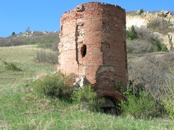
Picture

Historical snippets

  • The Long Expedition traveled through the Roxborough area in July of 1820.
  • Arapahoe, Cheyenne and Ute Indians made their home here until the 1860s.
  • The Slocum cabin, one of the oldest in Douglas County, was moved and remains standing in Chatfield State Park.
  • Kassler was once a town that supported the Denver area's first sand filtration plant.  Wooden pipes carried the filtered water into Denver.  The "leak gang" searched for leaks in the wooden pipes.
  • Waterton was once a thriving train stop on the Denver, South Park & Pacific rail line to Leadville.
  • One of the area's main industries was the Silicated Brick Company, that produced distinctive white bricks.  The kiln burned limestone into lime which was added to silica sand.  The bricks were not baked, but cured by a process using high pressure steam. The Kiln site was designated as a Douglas County historical landmark on August 22, 2007.
  • The small community supporting the miners and brickyard workers was named Silica.
  • A narrow gauge rail spur, the Silica Branch, of the Colorado and Southern Railway (formerly the Denver South Park & Pacific) was used to transport the bricks.
  • The remains of 24 Columbian Mammoths were discovered nearby at the Lamb Spring site.

 Roxborough Historama Map

Picture

In January 2021, a historama map created by Gladine Fritz Imes of the Roxborough Park area was installed at the Roxborough Park Community Center.

Ms. Imes served as a professor of art education at Casper College in Casper, Wyoming. In about 1960, the Imes family moved to Denver. We believe Ms. Imes became associated with Roxborough Park resident, Paul Jones and his exhibit firm, Condit Exhibits in the 1970s. Although it is undated, we believe it was during this period that Ms. Imes created the Roxborough Historama Map. There is speculation that the historama map may have been used in early Roxborough Park promotional materials. The Roxborough Historama Map became the property of Paul Jones and was gifted to the Roxborough Park Foundation by his wife, Patricia Jones in 2019.

Visit the historama map in its new location during regular Roxborough Park Community Center hours.


Copyright © 2023 · All Rights Reserved · Roxborough Area Historical Society

Non-profit and mailing address: 6237 Roxborough Dr., Roxborough, CO 80125
IRS non-profit certified under the 501(c)3 section of the Internal Revenue Code: EIN 26-0732544, DLN 26053463001725
Registered as a non-profit corporation in the State of Colorado: 20071378471
Proudly powered by Weebly